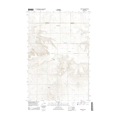
2014 Map of Acorn Flats
USGS Topo · Published 2014About this map
Acorn Flats defines this portion of the Montana high plains, where the boundary between Garfield and Rosebud Counties crosses a landscape of seasonal drainages and sharp relief. The terrain is marked by deep incisions such as Devils Canyon, which cuts through the central plateau near Miller Ranch Rd. Water is a scarce but vital resource, indicated by the presence of Wilkes Spring and the winding paths of Acorn Cr and Little Porcupine Cr. The road network, including Cohagen Rd and Acorn Flats Rd, follows the natural contours of the land, connecting isolated ranching sites across Germo Coulee and Hanson Coulee. This survey illustrates the spatial distribution of these named coulees and creeks, providing a clear picture of the area's geographic orientation in the early 21st century.
Find a feature on this map
15 named features on this map. Tap any name to fly to it.
Don’t see what you’re looking for? This feature index may not catch every label — zoom into the map to look around manually.
Map Details
Editions of this 2014 Acorn Flats Map
This is the sole edition of this map. No revisions or reprints were ever made.
Other maps of this area

1954 · Forsyth
USGS Topo · 1:250,000

1957 · Forsyth
USGS Topo · 1:250,000

1958 · Forsyth
USGS Topo · 1:250,000

1960 · Hagen Ranch
USGS Topo · 1:24,000

1960 · Brown Coulee
USGS Topo · 1:24,000

1965 · Acorn Flats
USGS Topo · 1:24,000

1965 · Kramer Ranch
USGS Topo · 1:24,000

1965 · Hole-In-The-Rock
USGS Topo · 1:24,000
1965 · School Butte
USGS Topo · 1:24,000
1965 · Mother Butte
USGS Topo · 1:24,000