
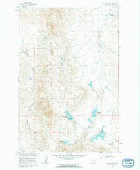
1960 Map of Brown Coulee
USGS Topo · Published 1962About this map
East Blacktail Creek and Brown Coulee dominate this 1960s landscape in Rosebud County, where the topography was carefully documented as part of the Missouri River Basin development program. The map illustrates a water-managed cattle ranching environment defined by a series of engineered catchments, including the Brown Coulee Reservoir, Blacktail Reservoir, and Lower Blacktail Reservoir. For local history researchers, the map provides precise locations for family settlements such as the Sweeter Homestead and Brockel Homestead, alongside the Blacktail Ranch. The rugged breaks of the Badland Coulee cut through the western edge of the sheet, contrasting with the more navigable plains to the east. Sparse industrial markers like Drill Hole 2798 suggest the era's subterranean explorations during this period of rural development.
Find a feature on this map
12 named features on this map. Tap any name to fly to it.
Don’t see what you’re looking for? This feature index may not catch every label — zoom into the map to look around manually.
Map Details
Editions of this 1960 Brown Coulee Map
2 editions found
Other maps of this area

1954 · Forsyth
USGS Topo · 1:250,000

1957 · Forsyth
USGS Topo · 1:250,000

1958 · Forsyth
USGS Topo · 1:250,000

1960 · Hagen Ranch
USGS Topo · 1:24,000

1960 · Thebes
USGS Topo · 1:24,000

1960 · Zempel Lake
USGS Topo · 1:24,000

1965 · Acorn Flats
USGS Topo · 1:24,000

1965 · Hole-In-The-Rock
USGS Topo · 1:24,000

1965 · Vanstel
USGS Topo · 1:24,000

1969 · Flat Bottom Coulee SW
USGS Topo · 1:24,000