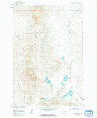
1960 Map of Brown Coulee
USGS Topo · Published 1962About this map
The semi-arid landscape of Rosebud County is defined here by a network of drainage channels and small-scale ranching developments. Surveyed as part of the Department of the Interior's efforts for the Missouri River Basin development, the map showcases the critical importance of water management in eastern Montana. A series of impoundments, including Brown Coulee Reservoir and Blacktail Reservoir, catch seasonal runoff from the surrounding uplands. These reservoirs, marked by specific elevations like Spillway 2807, provided vital water sources for the cattle operations that anchored the local economy.
Find a feature on this map
14 named features on this map. Tap any name to fly to it.
Don’t see what you’re looking for? This feature index may not catch every label — zoom into the map to look around manually.
Map Details
Editions of this 1960 Brown Coulee Map
2 editions found
Other maps of this area

1954 · Forsyth
USGS Topo · 1:250,000

1957 · Forsyth
USGS Topo · 1:250,000

1958 · Forsyth
USGS Topo · 1:250,000

1960 · Hagen Ranch
USGS Topo · 1:24,000

1960 · Thebes
USGS Topo · 1:24,000

1960 · Brown Coulee
USGS Topo · 1:24,000

1960 · Zempel Lake
USGS Topo · 1:24,000

1965 · Acorn Flats
USGS Topo · 1:24,000

1965 · Hole-In-The-Rock
USGS Topo · 1:24,000

1965 · Vanstel
USGS Topo · 1:24,000