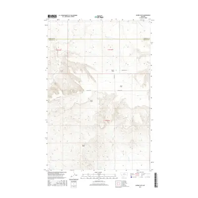
2017 Map of Acorn Flats
USGS Topo · Published 2017About this map
Acorn Flats defines this portion of the Montana high plains, where the Garfield Co Rosebud Co line divides the landscape into vast sections of open ranching country. The terrain is marked by significant erosion patterns, featuring Devils Canyon and various coulees such as Germo Coulee and Hanson Coulee that drain toward local watercourses. Sparse infrastructure is represented by a few key thoroughfares, including Acorn Flats Rd and Cohagon Rd, which provide access to remote properties like the one reached via Miller Ranch Ln. Water sources are critical in this arid environment, with Wilkes Spring serving as a vital landmark alongside Acorn Cr, Heist Cr, and Little Porcupine Cr. The map reflects the organized grid of the Public Land Survey System, illustrating how land ownership and agricultural use have been structured in this part of Rosebud and Garfield counties.
Find a feature on this map
15 named features on this map. Tap any name to fly to it.
Don’t see what you’re looking for? This feature index may not catch every label — zoom into the map to look around manually.
Map Details
Editions of this 2017 Acorn Flats Map
This is the sole edition of this map. No revisions or reprints were ever made.
Other maps of this area

1954 · Forsyth
USGS Topo · 1:250,000

1957 · Forsyth
USGS Topo · 1:250,000

1958 · Forsyth
USGS Topo · 1:250,000

1960 · Hagen Ranch
USGS Topo · 1:24,000

1960 · Brown Coulee
USGS Topo · 1:24,000

1965 · Acorn Flats
USGS Topo · 1:24,000

1965 · Kramer Ranch
USGS Topo · 1:24,000

1965 · Hole-In-The-Rock
USGS Topo · 1:24,000
1965 · School Butte
USGS Topo · 1:24,000
1965 · Mother Butte
USGS Topo · 1:24,000