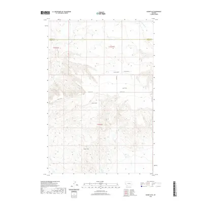
2020 Map of Acorn Flats
USGS Topo · Published 2020About this map
Acorn Flats straddles the boundary between Rosebud and Garfield counties, presenting a classic Big Sky landscape defined by deep drainages and remote ranching access. The northern portion of the map is dominated by the watershed of Heist Cr and Little Porcupine Cr, while the central terrain is deeply incised by Devils Canyon and Germa Coulee. This 2020 survey illustrates the modern persistence of traditional land use, where named access points like Miller Ranch Ln and Acorn Flats Rd provide the only infrastructure through the complex topography. Water remains the critical anchor for life here, marked by the presence of Wilkes Spring and Acorn Cr. The land's character is shaped by its drainage patterns, from the northern flats down through the Hanson Coulee in the south, reflecting a vast, open rangeland where cattle ranching and seasonal waterways define the local geography.
Find a feature on this map
12 named features on this map. Tap any name to fly to it.
Don’t see what you’re looking for? This feature index may not catch every label — zoom into the map to look around manually.
Map Details
Editions of this 2020 Acorn Flats Map
This is the sole edition of this map. No revisions or reprints were ever made.
Other maps of this area

1954 · Forsyth
USGS Topo · 1:250,000

1957 · Forsyth
USGS Topo · 1:250,000

1958 · Forsyth
USGS Topo · 1:250,000

1960 · Hagen Ranch
USGS Topo · 1:24,000

1960 · Brown Coulee
USGS Topo · 1:24,000

1965 · Acorn Flats
USGS Topo · 1:24,000

1965 · Kramer Ranch
USGS Topo · 1:24,000

1965 · Hole-In-The-Rock
USGS Topo · 1:24,000
1965 · School Butte
USGS Topo · 1:24,000
1965 · Mother Butte
USGS Topo · 1:24,000