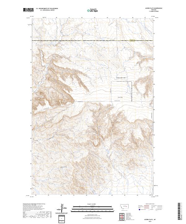
2024 Map of Acorn Flats
USGS Topo · Published 2024About this map
Acorn Flats defines this portion of the Montana plains, situated along the county line shared by Garfield and Rosebud counties. The landscape is characterized by its drainage network, where intermittent waters such as Acorn Creek and Heist Creek have carved significant features like Devils Canyon into the terrain. The presence of Wilkes Spring indicates the critical role of localized water sources in this arid environment, while the branching systems of Germo Coulee and Hanson Coulee demonstrate the complex erosion patterns typical of the region. This 2024 survey documents a territory where infrastructure remains sparse, primarily defined by the intersection of Cohagon Rd and Acorn Flats Rd, which facilitate movement across the sprawling sections of the Public Land Survey System.
Find a feature on this map
14 named features on this map. Tap any name to fly to it.
Don’t see what you’re looking for? This feature index may not catch every label — zoom into the map to look around manually.
Map Details
Editions of this 2024 Acorn Flats Map
This is the sole edition of this map. No revisions or reprints were ever made.
Other maps of this area

1954 · Forsyth
USGS Topo · 1:250,000

1957 · Forsyth
USGS Topo · 1:250,000

1958 · Forsyth
USGS Topo · 1:250,000

1960 · Hagen Ranch
USGS Topo · 1:24,000

1960 · Brown Coulee
USGS Topo · 1:24,000

1965 · Acorn Flats
USGS Topo · 1:24,000

1965 · Kramer Ranch
USGS Topo · 1:24,000

1965 · Hole-In-The-Rock
USGS Topo · 1:24,000
1965 · School Butte
USGS Topo · 1:24,000
1965 · Mother Butte
USGS Topo · 1:24,000