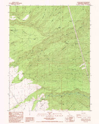
1985 Map of Acorn Hollow
USGS Topo · Published 1985About this map
Deer Creek and Mill Creek carve through this landscape in Tehama County, illustrating the remote and rugged character of Northern California during the mid-1980s. The map captures a transition between the elevated terrain of Allen Ridge and the broad expanses of Morris Flat, a region defined by seasonal watercourses like Big Dry Creek and Little Dry Creek. This survey records a sparse network of human habitation, including the Apperson Cabin and Favinger Place, alongside evidence of industrial and scientific activity such as a Gaging Station and various Quarries. A single Cem remains as a quiet marker of early settlement history in the region. The prevalence of 4WD tracks winding through Acorn Hollow and Twentymile Hollow highlights the area's utility for ranching, timber, or backcountry access before modern development could alter the drainage patterns of the Mt Diablo Meridian.
Find a feature on this map
44 named features on this map. Tap any name to fly to it.
Don’t see what you’re looking for? This feature index may not catch every label — zoom into the map to look around manually.
Map Details
Editions of this 1985 Acorn Hollow Map
2 editions found
Other maps of this area

1886 · Lassen Peak
USGS Topo · 1:250,000

1890 · Red Bluff
USGS Topo · 1:250,000

1891 · Chico
USGS Topo · 1:125,000

1892 · Lassen Peak
USGS Topo · 1:250,000

1893 · Chico
USGS Topo · 1:125,000

1894 · Lassen Peak
USGS Topo · 1:250,000

1894 · Red Bluff
USGS Topo · 1:250,000

1895 · Chico
USGS Topo · 1:125,000

1904 · Vina
USGS Topo · 1:62,500

1905 · Tehama
USGS Topo · 1:62,500