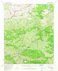
1959 Map of Acton
USGS Topo · Published 1966About this map
The Southern Pacific railroad corridor through Soledad Canyon anchors this high-country survey of the northern San Gabriel Mountains. While the town of Acton and the nearby settlement of Ravenna serve as the primary hubs for mining and ranching activity, the landscape is punctuated by isolated homesteads like Blum Ranch and Niles Ranch. High-altitude development is centered on forestry and recreation, evidenced by numerous stations such as the Mill Creek Ranger Sta and the Mount Gleason Military Reservation.
Find a feature on this map
80 named features on this map. Tap any name to fly to it.
Don’t see what you’re looking for? This feature index may not catch every label — zoom into the map to look around manually.
Map Details
Editions of this 1959 Acton Map
3 editions found
Other maps of this area

1894 · Los Angeles
USGS Topo · 1:62,500

1894 · Pomona
USGS Topo · 1:62,500

1896 · Pasadena
USGS Topo · 1:62,500

1896 · Santa Monica
USGS Topo · 1:62,500

1897 · Pomona
USGS Topo · 1:62,500

1898 · Pomona
USGS Topo · 1:62,500

1898 · Santa Monica
USGS Topo · 1:62,500

1900 · Pasadena
USGS Topo · 1:62,500

1900 · Tujunga
USGS Topo · 1:62,500

1900 · Los Angeles
USGS Topo · 1:62,500