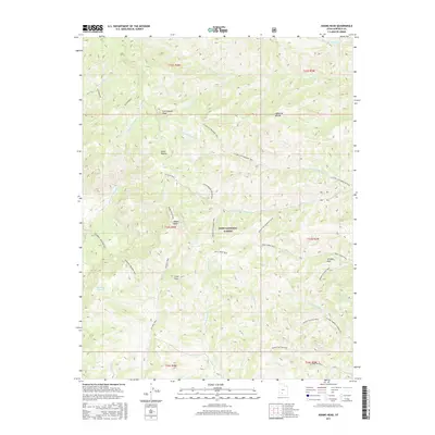
2017 Map of Adams Head
USGS Topo · Published 2017About this map
Dixie National Forest dominates this high-altitude landscape of the Sevier Plateau, where a complex network of pack trails and watercourses defines the terrain. The geography is anchored by prominent summits including Cottonwood Peak, Crow Peak, and the namesake Adams Head, which serves as a major landmark for the region. This survey illustrates a primitive transportation infrastructure consisting entirely of trails, such as the Adams Head Trail and the Mount Dutton Trail, which navigate between drainage systems like the N Fork Cottonwood Cr and Mountain Spring Fork. The concentration of named meadows and peaks, including Marshall Meadow and the distinctive Window Rock, suggests a landscape primarily utilized for seasonal grazing and forest management. Geologists and local historians can observe the intricate drainage patterns of the Right Fork Sanford Cr and Hancock Cr as they carve through the volcanic plateau.
Find a feature on this map
42 named features on this map. Tap any name to fly to it.
Don’t see what you’re looking for? This feature index may not catch every label — zoom into the map to look around manually.
Map Details
Editions of this 2017 Adams Head Map
This is the sole edition of this map. No revisions or reprints were ever made.
Other maps of this area

1885 · Beaver
USGS Topo · 1:250,000

1886 · Kanab
USGS Topo · 1:250,000

1953 · Richfield
USGS Topo · 1:250,000

1953 · Cedar City
USGS Topo · 1:250,000

1958 · Richfield
USGS Topo · 1:250,000

1958 · Cedar City
USGS Topo · 1:250,000

1962 · Cedar City
USGS Topo · 1:250,000

1966 · Bull Rush Peak
USGS Topo · 1:24,000
1971 · Flake Mtn East
USGS Topo · 1:24,000
1971 · Deep Creek
USGS Topo · 1:24,000