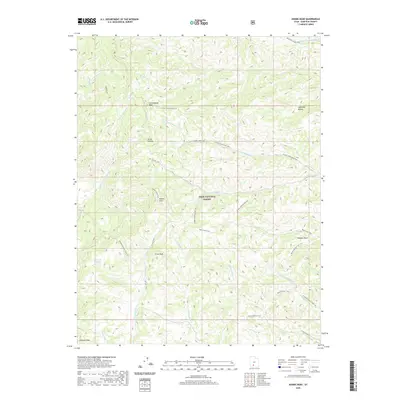
2020 Map of Adams Head
USGS Topo · Published 2020About this map
Dixie National Forest dominates this high-elevation landscape in Garfield County, where the southern reaches of the Sevier Plateau rise to prominent summits. Notable peaks such as Adams Head, Cottonwood Peak, and Crow Peak anchor a complex system of drainages, including the headwaters of Deer Cr and N Fork Cottonwood Cr. The map reveals an intricate network of backcountry access points, from the Marshall Meadow Trail to the long-reaching Mount Dutton Trail that traverses the southern terrain near Hancock Peak. Local landmarks like Window Rock and the grazing grounds of Marshall Meadow highlight the region's traditional uses. This survey is particularly useful for understanding the historic trail system and natural landmarks used for navigation across this portion of the plateau before modern development.
Find a feature on this map
38 named features on this map. Tap any name to fly to it.
Don’t see what you’re looking for? This feature index may not catch every label — zoom into the map to look around manually.
Map Details
Editions of this 2020 Adams Head Map
This is the sole edition of this map. No revisions or reprints were ever made.
Other maps of this area

1885 · Beaver
USGS Topo · 1:250,000

1886 · Kanab
USGS Topo · 1:250,000

1953 · Richfield
USGS Topo · 1:250,000

1953 · Cedar City
USGS Topo · 1:250,000

1958 · Richfield
USGS Topo · 1:250,000

1958 · Cedar City
USGS Topo · 1:250,000

1962 · Cedar City
USGS Topo · 1:250,000

1966 · Bull Rush Peak
USGS Topo · 1:24,000
1971 · Flake Mtn East
USGS Topo · 1:24,000
1971 · Deep Creek
USGS Topo · 1:24,000