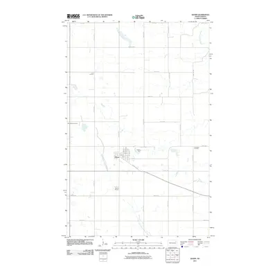
2011 Map of Adams
USGS Topo · Published 2011About this map
Adams is the primary settlement on this 2011 survey, situated within a landscape shaped by the branching headwaters of two separate drainage systems. The town is laid out on a grid including 1st Ave through 5th Ave, and is bordered by the Adams Dam and the winding course of the North Branch Forest River. This area of Walsh County preserves a distinct commemorative record with three separate burial grounds—Trinity Cemetery, West Adams Cemetery, and East Adams Cemetery—positioned on the outskirts of the main town site. Beyond the residential center, the terrain is defined by its agricultural section lines and water features like the South Branch Park River in the northeast corner. The presence of the Skyrud Skyway south of the village highlights the intersection of rural aviation with the traditional prairie landscape.
Find a feature on this map
24 named features on this map. Tap any name to fly to it.
Don’t see what you’re looking for? This feature index may not catch every label — zoom into the map to look around manually.
Map Details
Editions of this 2011 Adams Map
This is the sole edition of this map. No revisions or reprints were ever made.
Other maps of this area

1952 · Thief River Falls
USGS Topo · 1:250,000

1953 · Devils Lake
USGS Topo · 1:250,000

1956 · Thief River Falls
USGS Topo · 1:250,000

1956 · Devils Lake
USGS Topo · 1:250,000

1957 · Thief River Falls
USGS Topo · 1:250,000

1967 · Thief River Falls
USGS Topo · 1:250,000

1972 · Osnabrock SW
USGS Topo · 1:24,000

1972 · Adams
USGS Topo · 1:24,000
1972 · Edinburg NW
USGS Topo · 1:24,000

1972 · Adams SW
USGS Topo · 1:24,000