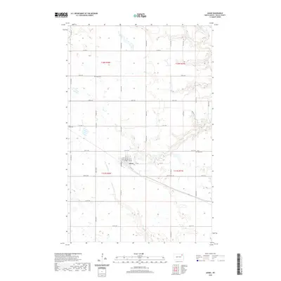
2020 Map of Adams
USGS Topo · Published 2020About this map
Adams serves as the central hub of this prairie landscape, where the grid of Walsh County roads meets a localized network of streets including Kongsberg St, Vesta St, and Parup St. The surrounding agricultural landscape is defined by its subtle hydrology, with the S Br Park River draining the northern reaches and the N Br Forest River winding through the south. This 2020 record documents the spatial layout of the community, which is anchored by several burial grounds including Trinity Cem to the north and the West Adams Cem and East Adams Cem flanking the town site. The map captures the persistent section-line road system that organizes the region, punctuated by routes like Co Hwy 9 and Walsh Co Rd 11A, illustrating the enduring intersection of rural transportation and small-town settlement in North Dakota.
Find a feature on this map
39 named features on this map. Tap any name to fly to it.
Don’t see what you’re looking for? This feature index may not catch every label — zoom into the map to look around manually.
Map Details
Editions of this 2020 Adams Map
This is the sole edition of this map. No revisions or reprints were ever made.
Other maps of this area

1952 · Thief River Falls
USGS Topo · 1:250,000

1953 · Devils Lake
USGS Topo · 1:250,000

1956 · Thief River Falls
USGS Topo · 1:250,000

1956 · Devils Lake
USGS Topo · 1:250,000

1957 · Thief River Falls
USGS Topo · 1:250,000

1967 · Thief River Falls
USGS Topo · 1:250,000

1972 · Osnabrock SW
USGS Topo · 1:24,000

1972 · Adams
USGS Topo · 1:24,000
1972 · Edinburg NW
USGS Topo · 1:24,000

1972 · Adams SW
USGS Topo · 1:24,000