1977 Map of Adamson
USGS Topo · Published 1977About this map
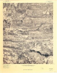
Adamson and Dow sit at the center of this 1977 orthophotoquad, which uses rectified aerial imagery to reveal the textured landscape of eastern Oklahoma. The map is dominated by the massive physical presence of Buffalo Mountain, a broad ridge that separates the northern and southern drainage basins of the area. To the west, the expansive waters of Eufaula Lake begin to reach into the valley, reflecting the significant hydrological changes brought by the damming of the Canadian River system. This transition from high timbered ridges to the alluvial flats of Gaines Creek and Brushy Creek illustrates the topographical variety found within Pittsburg County. For researchers, the imagery provides a clear look at the late 1970s land use, showing the distribution of woodlots, cleared fields, and the winding courses of Ash Creek as it flows toward the reservoir.
Find a feature on this map
7 named features on this map. Tap any name to fly to it.
Don’t see what you’re looking for? This feature index may not catch every label — zoom into the map to look around manually.
Map Details
Editions of this 1977 Adamson Map
This is the sole edition of this map. No revisions or reprints were ever made.
Other maps of this area

1898 · McAlester
USGS Topo · 1:125,000

1900 · Sansbois
USGS Topo · 1:125,000

1900 · Canadian
USGS Topo · 1:125,000

1901 · Tuskahoma
USGS Topo · 1:125,000

1908 · Tuskahoma
USGS Topo · 1:125,000

1909 · Mc Alester
USGS Topo · 1:125,000

1909 · Tuskahoma
USGS Topo · 1:125,000

1909 · Sans Bois
USGS Topo · 1:125,000

1911 · Sansbois
USGS Topo · 1:125,000

1946 · Fort Smith
USGS Topo · 1:250,000