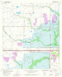
1970 Map of Addicks
USGS Topo · Published 1980About this map
Addicks Reservoir and Barker Reservoir dominate this West Houston landscape, revealing the critical flood control infrastructure of the mid-20th century. While large portions of the area are dedicated to these basins and Bear Creek Park, the map also documents the encroachment of Houston corporate boundaries and residential expansion shown in purple revision tints. The small settlement of Addicks sits near the junction of the Missouri - Kansas - Texas railroad and Highway 6, serving as a focal point for the surrounding rural roads. Local history is anchored by landmarks like the Baker Cem and the small Graves settlement. The hydrology is intricate, with South Mayde Creek, Bear Creek, and Langham Creek feeding into the reservoirs, while Buffalo Bayou emerges downstream of the Barker Dam. Transportation history is visible through a network of family-named routes such as Gummert Rd and Gertie Rice Road.
Find a feature on this map
28 named features on this map. Tap any name to fly to it.
Don’t see what you’re looking for? This feature index may not catch every label — zoom into the map to look around manually.
Map Details
Editions of this 1970 Addicks Map
4 editions found
Other maps of this area

1915 · Alief
USGS Topo · 1:24,000

1915 · Cypress
USGS Topo · 1:24,000

1915 · Katy
USGS Topo · 1:24,000

1915 · Addicks
USGS Topo · 1:24,000

1915 · Hillendahl
USGS Topo · 1:24,000

1915 · Clodine
USGS Topo · 1:24,000

1916 · Satsuma
USGS Topo · 1:24,000

1916 · Swanson
USGS Topo · 1:24,000

1918 · Cypress
USGS Topo · 1:31,680

1918 · Addicks
USGS Topo · 1:31,680