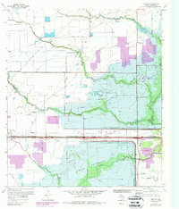
1970 Map of Addicks
USGS Topo · Published 1987About this map
Addicks Reservoir and Barker Reservoir dominate this western Harris County landscape, showcasing the massive flood control infrastructure designed to protect the growing Houston area. This 1970 survey, with purple revisions from 1977, captures the transition of rural Texas prairie into a managed watershed. The Addicks Dam and Barker Dam structures bisect the terrain, while numerous watercourses like South Mayde Creek and Buffalo Bayou wind through the retention basins. Local history is preserved in features like the Baker Cem near the southern edge and the Missouri - Kansas - Texas railroad line. As Houston's corporate boundaries pushed westward, formerly isolated landmarks such as Lakeside Airport and family-named routes like Gummert Rd and Gertie Rice Road were gradually absorbed into the suburban fringe of Addicks.
Find a feature on this map
26 named features on this map. Tap any name to fly to it.
Don’t see what you’re looking for? This feature index may not catch every label — zoom into the map to look around manually.
Map Details
Editions of this 1970 Addicks Map
4 editions found
Other maps of this area

1915 · Alief
USGS Topo · 1:24,000

1915 · Cypress
USGS Topo · 1:24,000

1915 · Katy
USGS Topo · 1:24,000

1915 · Addicks
USGS Topo · 1:24,000

1915 · Hillendahl
USGS Topo · 1:24,000

1915 · Clodine
USGS Topo · 1:24,000

1916 · Satsuma
USGS Topo · 1:24,000

1916 · Swanson
USGS Topo · 1:24,000

1918 · Cypress
USGS Topo · 1:31,680

1918 · Addicks
USGS Topo · 1:31,680