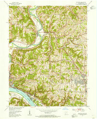
1954 Map of Addyston
USGS Topo · Published 1955About this map
Addyston and the surrounding riverfront communities along the Ohio River and Miami River are defined by a complex network of industrial and transport infrastructure in the mid-1950s. The landscape is characterized by the confluence of major rail lines, including the Baltimore and Ohio and the Chesapeake and Ohio, which follow the river valleys through settlements like North Bend and Miamitown. The interior terrain rises into the hills of Green and Whitewater townships, where suburban expansion is visible in Bridgetown and Mack. Local history is preserved in sites such as Bethel Cem, Miamitown Cem, and the Zion Ch. The map also reveals the rural-to-suburban transition with numerous educational institutions like Township Sch and Springmeyer Sch serving growing neighborhoods alongside more traditional features like the Gravel Pits and the sprawling Miami Whitewater Forest.
Find a feature on this map
53 named features on this map. Tap any name to fly to it.
Don’t see what you’re looking for? This feature index may not catch every label — zoom into the map to look around manually.
Map Details
Editions of this 1954 Addyston Map
This is the sole edition of this map. No revisions or reprints were ever made.
Other maps of this area

1914 · West Cincinnati
USGS Topo · 1:62,500

1915 · Lawrenceburg
USGS Topo · 1:48,000

1915 · Harrison
USGS Topo · 1:48,000

1915 · Hamilton
USGS Topo · 1:62,500

1917 · Hamilton
USGS Topo · 1:62,500

1928 · Lawrenceburg
USGS Topo · 1:62,500

1932 · Lawrenceburg
USGS Topo · 1:62,500

1943 · Hooven
USGS Topo · 1:24,000

1943 · Lawrenceburg
USGS Topo · 1:24,000

1950 · Covington
USGS Topo · 1:24,000