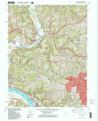
1996 Map of Addyston
USGS Topo · Published 1999About this map
Great Miami River and Ohio River valley geography dominates this late 20th-century landscape, where industrial sites like Miami Station and several Gravel Pits sit alongside suburban expansion. The western edge of Cincinnati is visible near Cheviot and Bridgetown, while the riverbottoms host infrastructure like the Sewage Disposal plant and the CSX rail line. Local history is anchored by numerous community sites, including Miamitown Ch and several small burial grounds such as Whitney Cem and Bethel Cem. Cultural landmarks of the era include a Drive-in Theater near Dent and several parochial and public institutions like Our Lady of Visitation Sch and Oak Hill High Sch. The map reveals the dense road network connecting older settlements like Cleves and Addyston to large protected tracts including Miami Whitewater Forest and Mitchell Memorial Forest.
Find a feature on this map
59 named features on this map. Tap any name to fly to it.
Don’t see what you’re looking for? This feature index may not catch every label — zoom into the map to look around manually.
Map Details
Editions of this 1996 Addyston Map
This is the sole edition of this map. No revisions or reprints were ever made.
Other maps of this area

1914 · West Cincinnati
USGS Topo · 1:62,500

1915 · Lawrenceburg
USGS Topo · 1:48,000

1915 · Harrison
USGS Topo · 1:48,000

1915 · Hamilton
USGS Topo · 1:62,500

1917 · Hamilton
USGS Topo · 1:62,500

1928 · Lawrenceburg
USGS Topo · 1:62,500

1932 · Lawrenceburg
USGS Topo · 1:62,500

1943 · Hooven
USGS Topo · 1:24,000

1943 · Lawrenceburg
USGS Topo · 1:24,000

1950 · Covington
USGS Topo · 1:24,000