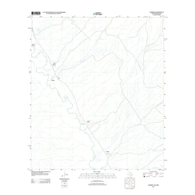
2012 Map of Adobes
USGS Topo · Published 2012About this map
Rio Grande waters define the international borderlands shown in this survey, where the river winds through a desert landscape of deep arroyos and canyons. Small settlements like Chinati and Adobes are positioned near the river, reflecting a long-standing reliance on its flow for life in this arid region. The presence of multiple burial grounds, including the Chinati Cem, Adobe Cem, and Adobes Cem, provides significant genealogical value for those tracing families in this remote stretch of the Big Bend area.
Find a feature on this map
12 named features on this map. Tap any name to fly to it.
Don’t see what you’re looking for? This feature index may not catch every label — zoom into the map to look around manually.
Map Details
Editions of this 2012 Adobes Map
This is the sole edition of this map. No revisions or reprints were ever made.
Other maps of this area

1896 · Ruidosa
USGS Topo · 1:125,000

1896 · Shafter
USGS Topo · 1:125,000

1959 · Presidio
USGS Topo · 1:250,000

1965 · Presidio
USGS Topo · 1:250,000

1966 · Adobes
USGS Topo · 1:24,000

1978 · Sierra Parda
USGS Topo · 1:24,000
1979 · Indio
USGS Topo · 1:24,000
1979 · Chinati Peak
USGS Topo · 1:24,000

1980 · Arroyo Melado
USGS Topo · 1:24,000
1980 · Las Conchas
USGS Topo · 1:24,000