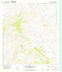
1979 Map of Chinati Peak
USGS Topo · Published 1979About this map
Chinati Peak towers over this section of the High Desert in Presidio County, providing a dominant landmark for the isolated ranches and watering holes of the Trans-Pecos. The landscape is defined by the steep relief of the Chinati Mountains, where narrow drainages like Pinto Canyon and Mayo Canyon cut through the terrain. Human presence is sparse but concentrated around essential water sources and resource extraction, including the San Antonio Mine and several water-retention features known as presas, such as Presa Llorona and Presa Viruelas. Remote habitations like Chaffin Place and Wood Ranch rely on a network of primitive transportation, from a lonely Landing Strip to numerous pack trails and jeep tracks. The presence of a small Cem near the northern boundary and the Ojo Bonito settlement reflect the enduring, if scattered, history of cattle ranching and silver mining in this arid borderlands region.
Find a feature on this map
35 named features on this map. Tap any name to fly to it.
Don’t see what you’re looking for? This feature index may not catch every label — zoom into the map to look around manually.
Map Details
Editions of this 1979 Chinati Peak Map
This is the sole edition of this map. No revisions or reprints were ever made.
Other maps of this area

1895 · Marfa
USGS Topo · 1:125,000

1896 · Ruidosa
USGS Topo · 1:125,000

1896 · San Carlos
USGS Topo · 1:125,000

1896 · Shafter
USGS Topo · 1:125,000

1959 · Presidio
USGS Topo · 1:250,000

1959 · Marfa
USGS Topo · 1:250,000

1965 · Presidio
USGS Topo · 1:250,000

1965 · Marfa
USGS Topo · 1:250,000

1966 · Adobes
USGS Topo · 1:24,000

1978 · Sierra Parda
USGS Topo · 1:24,000