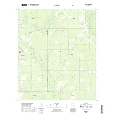
2018 Map of Afeman
USGS Topo · Published 2018About this map
Mount Moriah Cem and Upper Mount Moriah Cem stand as central landmarks in this rural landscape along the border of Vernon and Rapides Parishes. This portion of the Kisatchie National Forest is defined by a dense network of creek branches and timbered terrain, where small settlements like Afeman and Cora are linked by gravel parish roads and forest service routes. To the west, the boundary of Fort Polk meets the forest, illustrating the region's dual identity as a public wilderness and a military training area. The drainage pattern is particularly intricate, with Tenmile Cr and Big Cr carving through the piney woods. Numerous family-named roads, such as Lonzie Doyle Rd and Chester Merchant Rd, reflect the local genealogy and the persistent footprint of long-standing resident families in this corner of central Louisiana.
Find a feature on this map
50 named features on this map. Tap any name to fly to it.
Don’t see what you’re looking for? This feature index may not catch every label — zoom into the map to look around manually.
Map Details
Editions of this 2018 Afeman Map
This is the sole edition of this map. No revisions or reprints were ever made.
Other maps of this area

1935 · Pawnee
USGS Topo · 1:31,680

1942 · Oakdale
USGS Topo · 1:62,500

1943 · Leander
USGS Topo · 1:62,500

1947 · Steep Gully
USGS Topo · 1:31,680

1947 · Pitkin
USGS Topo · 1:31,680
1951 · Pitkin
USGS Topo · 1:24,000

1951 · Steep Gully
USGS Topo · 1:24,000

1952 · Lake Charles
USGS Topo · 1:250,000

1953 · Alexandria
USGS Topo · 1:250,000
1954 · Pawnee
USGS Topo · 1:31,680