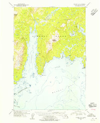
1954 Map of Afognak A-2
USGS Topo · Published 1955About this map
Afognak Island reveals its complex maritime and mountainous geography in this mid-century coastal survey. The island landscape is dominated by the steep rises of Paramanof Mountain and Duck Mountain, both situated within the Chugach National Forest. Evidence of early industrial and subsistence activity is found at the Hatchery near Kitoi Bay and several small Cabin sites along the intricate shoreline. The maritime environment is exceptionally detailed, recording numerous hazards such as Shipwith Reefs, Big Rock, and Stripe Rock within the waters of Marmot Bay. Geographers can trace the distinct indentations of the coast from the deep waters of Kazakof Bay to the smaller inlets of Mary Anderson Cove and Selezen Bay, providing a clear view of the island's isolation and its reliance on the surrounding sea in the 1950s.
Find a feature on this map
30 named features on this map. Tap any name to fly to it.
Don’t see what you’re looking for? This feature index may not catch every label — zoom into the map to look around manually.
Map Details
Editions of this 1954 Afognak A-2 Map
This is the sole edition of this map. No revisions or reprints were ever made.
Other maps of this area

1947 · Kodiak D-3
USGS Topo · 1:63,360

1949 · Kodiak D-2
USGS Topo · 1:63,360

1949 · Kodiak D-3
USGS Topo · 1:63,360

1949 · Kodiak D-1
USGS Topo · 1:63,360

1950 · Kodiak D-3
USGS Topo · 1:63,360

1951 · Kodiak D-1
USGS Topo · 1:63,360

1951 · Kodiak D-2
USGS Topo · 1:63,360

1952 · Kodiak
USGS Topo · 1:250,000

1952 · Afognak
USGS Topo · 1:250,000

1952 · Afognak A-3
USGS Topo · 1:63,360