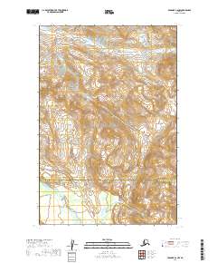
2019 Map of Afognak C-6 NW
USGS Topo · Published 2019About this map
Katmai National Park dominates the central landscape of this wilderness survey, where the dramatic terrain is defined by the headwaters of several remote river systems. Flowing through the northern reaches, the S Fork Kamishak River carves its way through steep elevation contours, while the Big River drains the southwestern portion of the map. This area serves as a significant administrative transition point, as evidenced by the boundary line between the Kenai Peninsula Borough and the Kodiak Island Borough. The map provides a precise look at the topographical character of the Alaska Peninsula, illustrating the complex drainage patterns and high-altitude ridges that separate these protected glacial and volcanic landscapes near the turn of the decade.
Find a feature on this map
10 named features on this map. Tap any name to fly to it.
Don’t see what you’re looking for? This feature index may not catch every label — zoom into the map to look around manually.
Map Details
Editions of this 2019 Afognak C-6 NW Map
This is the sole edition of this map. No revisions or reprints were ever made.
Other maps of this area

1948 · Mt Katmai
USGS Topo · 1:250,000

1951 · Mt Katmai
USGS Topo · 1:250,000

1951 · Afognak C-6
USGS Topo · 1:63,360

1951 · Mount Katmai D-1
USGS Topo · 1:63,360

1951 · Mount Katmai C-1
USGS Topo · 1:63,360

1951 · Afognak D-6
USGS Topo · 1:63,360

1952 · Afognak
USGS Topo · 1:250,000
1953 · Mount Katmai D-1
USGS Topo · 1:63,360

1964 · Mt. Katmai
USGS Topo · 1:250,000
1983 · Afognak D-6
USGS Topo · 1:63,360