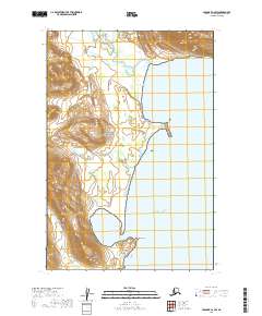
2019 Map of Afognak C-6 SW
USGS Topo · Published 2019About this map
Katmai National Park encompasses the western portion of this coastal survey, where the rugged Alaskan shoreline meets the Pacific Ocean. The geography is defined by the transition from steep coastal mountains to the tidal flats of Swikshak Bay. To the north, the Big River flows toward the coast through a series of braided channels and low-lying wetlands. The southern edge of the bay is marked by Cape Chiniak, a prominent landform that shelters the inner waters of the bay from the open ocean. This 2019 survey documents a landscape preserved in its natural state, devoid of established roads or permanent settlements, where the primary features are the intersection of glacial-fed river systems and the sea.
Find a feature on this map
9 named features on this map. Tap any name to fly to it.
Don’t see what you’re looking for? This feature index may not catch every label — zoom into the map to look around manually.
Map Details
Editions of this 2019 Afognak C-6 SW Map
This is the sole edition of this map. No revisions or reprints were ever made.
Other maps of this area

1948 · Mt Katmai
USGS Topo · 1:250,000

1951 · Mt Katmai
USGS Topo · 1:250,000

1951 · Afognak C-6
USGS Topo · 1:63,360

1951 · Mount Katmai C-1
USGS Topo · 1:63,360

1951 · Mount Katmai B-1
USGS Topo · 1:63,360

1952 · Afognak
USGS Topo · 1:250,000

1964 · Mt. Katmai
USGS Topo · 1:250,000
2019 · Mount Katmai C-1 SE
USGS Topo · 1:25,000
2019 · Mount Katmai C-1 NE
USGS Topo · 1:25,000
2019 · Mount Katmai B-1 NE
USGS Topo · 1:25,000