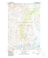
1983 Map of Afognak D-6
USGS Topo · Published 1988About this map
The Douglas River winds through the heart of this coastal Alaskan landscape, carving a wide valley through the eastern reaches of the Katmai National Park. Established under the Alaska National Interest Lands Conservation Act of 1980, these protected grounds include the expansive Katmai Wilderness, a territory defined by high-elevation glaciers and steep glacial valleys. In the southeastern corner of the map, Fourpeaked Mountain stands as a prominent topographical feature, its permanent ice fields feeding the drainage systems that flow toward the coast. The absence of roads or established trails highlights the preservation of this coastal wilderness as it was during the early 1980s.
Find a feature on this map
4 named features on this map. Tap any name to fly to it.
Don’t see what you’re looking for? This feature index may not catch every label — zoom into the map to look around manually.
Map Details
Editions of this 1983 Afognak D-6 Map
This is the sole edition of this map. No revisions or reprints were ever made.
Other maps of this area

1948 · Mt Katmai
USGS Topo · 1:250,000

1951 · Mt Katmai
USGS Topo · 1:250,000

1951 · Afognak C-6
USGS Topo · 1:63,360
1951 · Afognak C-5
USGS Topo · 1:63,360

1951 · Mount Katmai D-1
USGS Topo · 1:63,360

1951 · Iliamna A-3
USGS Topo · 1:63,360

1951 · Iliamna A-1 and A-2
USGS Topo · 1:63,360

1951 · Mount Katmai C-1
USGS Topo · 1:63,360

1951 · Afognak D-5
USGS Topo · 1:63,360

1951 · Afognak D-6
USGS Topo · 1:63,360