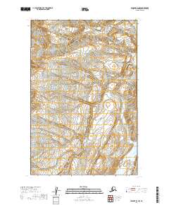
2019 Map of Afognak D-6 NW
USGS Topo · Published 2019About this map
Katmai National Park encompasses the vast majority of this 2019 landscape, revealing the high-elevation topography and glacially carved valleys of the Kenai Peninsula. The terrain is defined by steep contour lines rising from the Douglas River valley in the southeast, where the drainage weaves through the foothills before exiting the quadrangle. As a modern US Topo survey, this sheet provides an exacting look at the wild, uninhabited interior of the park, where public land systems like t14s r28w and t15s r28w provide the only formal structure across the unpopulated mountain passes and ridge lines.
Find a feature on this map
7 named features on this map. Tap any name to fly to it.
Don’t see what you’re looking for? This feature index may not catch every label — zoom into the map to look around manually.
Map Details
Editions of this 2019 Afognak D-6 NW Map
This is the sole edition of this map. No revisions or reprints were ever made.
Other maps of this area

1948 · Mt Katmai
USGS Topo · 1:250,000

1951 · Mt Katmai
USGS Topo · 1:250,000

1951 · Mount Katmai D-1
USGS Topo · 1:63,360

1951 · Iliamna A-3
USGS Topo · 1:63,360

1951 · Afognak D-6
USGS Topo · 1:63,360

1952 · Iliamna
USGS Topo · 1:250,000

1952 · Afognak
USGS Topo · 1:250,000
1953 · Mount Katmai D-1
USGS Topo · 1:63,360

1957 · Iliamna
USGS Topo · 1:250,000

1964 · Mt. Katmai
USGS Topo · 1:250,000