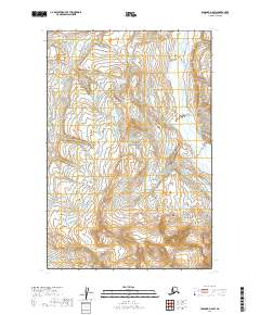
2019 Map of Afognak D-6 SW
USGS Topo · Published 2019About this map
Katmai National Park encompasses the majority of this coastal Alaskan landscape, where the Douglas River carves through high-elevation terrain near the eastern edge of the Alaska Peninsula. The topography is dominated by steep ridges and glacial valleys, with elevation contours reflecting a vertical rise from the river basin into the surrounding peaks. This 2019 survey documents a wilderness environment largely defined by its natural hydrology and the absence of established roads or permanent settlements. The administrative boundaries of t15s r28w and t16s r28w provide the primary spatial framework for this remote section of the Kenai Peninsula Borough, which remains dedicated to conservation and the preservation of its rugged maritime ecosystems.
Find a feature on this map
6 named features on this map. Tap any name to fly to it.
Don’t see what you’re looking for? This feature index may not catch every label — zoom into the map to look around manually.
Map Details
Editions of this 2019 Afognak D-6 SW Map
This is the sole edition of this map. No revisions or reprints were ever made.
Other maps of this area

1948 · Mt Katmai
USGS Topo · 1:250,000

1951 · Mt Katmai
USGS Topo · 1:250,000

1951 · Afognak C-6
USGS Topo · 1:63,360

1951 · Mount Katmai D-1
USGS Topo · 1:63,360

1951 · Mount Katmai C-1
USGS Topo · 1:63,360

1951 · Afognak D-6
USGS Topo · 1:63,360

1952 · Afognak
USGS Topo · 1:250,000
1953 · Mount Katmai D-1
USGS Topo · 1:63,360

1964 · Mt. Katmai
USGS Topo · 1:250,000
1983 · Afognak D-6
USGS Topo · 1:63,360