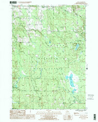
1986 Map of Afton
USGS Topo · Published 1986About this map
Mackinaw State Forest dominates this northern Michigan landscape, where the Pigeon River and its tributaries carve through the timberlands of Cheboygan County. The settlement of Afton sits at the northwestern edge of the map, while Fingerboard Corner and Kimberly mark crossroads within the wooded interior. This mid-1980s survey illustrates a landscape primarily defined by water and forest management, featuring numerous lakes such as Dog Lake, Lake Sixteen, and Osmun Lake. A clear industrial and transit history is evidenced by an Old RR Grade cutting through the southeastern sections near W McMasters Creek, providing a tangible link for those researching the region's logging or rail heritage. The presence of a Gravel Pit and a Radio Tower suggests the modern utilitarian uses of the land amidst the broader wilderness areas.
Find a feature on this map
26 named features on this map. Tap any name to fly to it.
Don’t see what you’re looking for? This feature index may not catch every label — zoom into the map to look around manually.
Map Details
Editions of this 1986 Afton Map
2 editions found
Other maps of this area

1954 · Gaylord
USGS Topo · 1:62,500

1954 · Hetherton
USGS Topo · 1:62,500

1955 · Cheboygan
USGS Topo · 1:250,000

1957 · Tower
USGS Topo · 1:62,500

1957 · Wolverine
USGS Topo · 1:62,500

1958 · Cheboygan
USGS Topo · 1:250,000

1982 · Petoskey
USGS Topo · 1:100,000

1986 · Silver Lake
USGS Topo · 1:24,000
1986 · Legrand
USGS Topo · 1:24,000
1986 · Tower
USGS Topo · 1:24,000