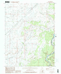
1985 Map of Agate
USGS Topo · Published 1986About this map
Colorado River Canyon dominates the southeastern corner of this Grand County landscape, where the Little Dolores River joins the primary flow. This 1980s provisional study captures a rugged stretch of Utah desert defined by deep drainages and industrial infrastructure. An Old Railroad Grade winds through the central terrain, tracing a historical transportation route that once negotiated the complex topography between Cottonwood Wash and the river.
Find a feature on this map
14 named features on this map. Tap any name to fly to it.
Don’t see what you’re looking for? This feature index may not catch every label — zoom into the map to look around manually.
Map Details
Editions of this 1985 Agate Map
This is the sole edition of this map. No revisions or reprints were ever made.
Other maps of this area

1885 · East Tavaputs
USGS Topo · 1:250,000

1885 · La Sal
USGS Topo · 1:250,000

1954 · Westwater 4 SW
USGS Topo · 1:24,000

1954 · Mt. Waas 1 NE
USGS Topo · 1:24,000

1954 · Mt. Waas 1 NW
USGS Topo · 1:24,000

1954 · Coates Creek
USGS Topo · 1:62,500

1956 · Westwater 4 SE
USGS Topo · 1:24,000

1956 · Moab
USGS Topo · 1:250,000

1956 · Grand Junction
USGS Topo · 1:250,000

1958 · Cisco
USGS Topo · 1:62,500