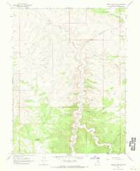
1966 Map of Agency Draw NE
USGS Topo · Published 1970About this map
The Agency Draw Oil Field defines the industrial footprint of this high desert landscape, where a Gas Well and early extraction infrastructure sit alongside traditional ranching features. This mid-1960s survey of Uintah County captures a transition as modern energy exploration began to overlay established backcountry routes. Willow Creek snakes through the center of the sheet, creating a deep canyon system that dictates the placement of landmarks like Santio Crossing and the Stevens Ranch. High points such as Chimney Rock and Blue Knoll provide navigational aids in a terrain marked by deep washes like Sunday School Canyon and Wood Canyon. Evidence of livestock management is visible at Brown Corral, while a Pipeline and various Jeep Trails suggest the increasing connectivity of the Seep Ridge area during this period.
Find a feature on this map
20 named features on this map. Tap any name to fly to it.
Don’t see what you’re looking for? This feature index may not catch every label — zoom into the map to look around manually.
Map Details
Editions of this 1966 Agency Draw NE Map
This is the sole edition of this map. No revisions or reprints were ever made.
Other maps of this area

1885 · East Tavaputs
USGS Topo · 1:250,000

1956 · Grand Junction
USGS Topo · 1:250,000

1959 · Grand Junction
USGS Topo · 1:250,000

1960 · Grand Junction
USGS Topo · 1:250,000

1962 · Grand Junction
USGS Topo · 1:250,000

1964 · Grand Junction
USGS Topo · 1:250,000

1965 · Grand Junction
USGS Topo · 1:250,000
1966 · Bates Knolls
USGS Topo · 1:24,000
1966 · Wolf Point
USGS Topo · 1:24,000
1966 · Flat Rock Mesa
USGS Topo · 1:24,000