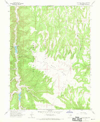
1966 Map of Flat Rock Mesa
USGS Topo · Published 1970About this map
The Flat Rock Oil Field defines the industrial footprint of this mid-century landscape, positioned atop the expansive high ground of Flat Rock Mesa. Situated within the Uintah and Ouray Indian Reservation, the map records a network of petroleum infrastructure including an Oil Well and various drill holes scattered near Wilcox Canyon. These modern developments contrast with the traditional topography of the Book Cliffs region, where deep drainages like Hill Creek and Agency Draw carve through the plateau. Water resources are central to the area's utility, marked by Towave Reservoir and Flat Rock Spring. The presence of School Section Canyon and Mail Canyon suggests the historical pathways and administrative divisions established during the mid-1960s when this survey was conducted.
Find a feature on this map
24 named features on this map. Tap any name to fly to it.
Don’t see what you’re looking for? This feature index may not catch every label — zoom into the map to look around manually.
Map Details
Editions of this 1966 Flat Rock Mesa Map
This is the sole edition of this map. No revisions or reprints were ever made.
Other maps of this area

1885 · East Tavaputs
USGS Topo · 1:250,000

1953 · Firewater Canyon
USGS Topo · 1:62,500

1956 · Grand Junction
USGS Topo · 1:250,000

1959 · Grand Junction
USGS Topo · 1:250,000

1960 · Grand Junction
USGS Topo · 1:250,000

1962 · Grand Junction
USGS Topo · 1:250,000

1963 · Tenmile Canyon
USGS Topo · 1:62,500

1963 · Moonwater Point
USGS Topo · 1:62,500

1964 · Grand Junction
USGS Topo · 1:250,000

1965 · Grand Junction
USGS Topo · 1:250,000