
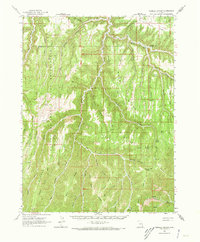
1963 Map of Tenmile Canyon
USGS Topo · Published 1965About this map
The eastern expanse of the Uintah and Ouray Indian Reservation dominates this 1963 survey, where high desert plateaus are dissected by an intricate network of drainages. The landscape is defined by massive topographic features such as Steer Ridge, Moon Ridge, and Winter Ridge, which separate deep canyons like Tenmile Canyon and Moon Ridge Canyon. This era of mapping shows the intersection of natural isolation and early industrial activity, noted by several remote landing strips, a Drill Hole, and an Oil Well tucked into the canyon floor.
Find a feature on this map
54 named features on this map. Tap any name to fly to it.
Don’t see what you’re looking for? This feature index may not catch every label — zoom into the map to look around manually.
Map Details
Editions of this 1963 Tenmile Canyon Map
2 editions found
Other maps of this area

1885 · East Tavaputs
USGS Topo · 1:250,000

1953 · Firewater Canyon
USGS Topo · 1:62,500

1956 · Grand Junction
USGS Topo · 1:250,000

1959 · Grand Junction
USGS Topo · 1:250,000

1960 · Grand Junction
USGS Topo · 1:250,000

1962 · Grand Junction
USGS Topo · 1:250,000

1963 · Moonwater Point
USGS Topo · 1:62,500
1963 · Floy Canyon
USGS Topo · 1:62,500

1963 · Sego Canyon
USGS Topo · 1:62,500

1964 · Grand Junction
USGS Topo · 1:250,000