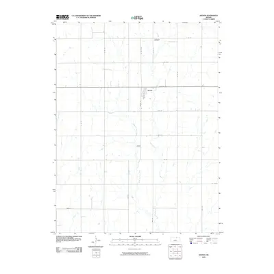
2009 Map of Agenda
USGS Topo · Published 2009About this map
The small town of Agenda serves as the central point of this agricultural landscape in Republic County. Organized around a grid of section roads and rural routes like Wagon Rd, the area maintains its rural character through established burial grounds such as Willoughby Cemetery in the north and Agenda Cemetery to the south. The drainage of the land is defined by the winding paths of Elk Creek and its tributary, West Fork Elk Creek, which carve gentle patterns across the terrain. While State Hwy 148 provides the primary east-west corridor, the map details a dense network of county roads like Co Rd W and Co Rd 27, illustrating the systematic land division typical of the Kansas prairie. This survey captures the town at the end of the first decade of the 21st century, showing the enduring spatial relationship between the village and its surrounding farmsteads.
Find a feature on this map
24 named features on this map. Tap any name to fly to it.
Don’t see what you’re looking for? This feature index may not catch every label — zoom into the map to look around manually.
Map Details
Editions of this 2009 Agenda Map
This is the sole edition of this map. No revisions or reprints were ever made.
Other maps of this area

1892 · Concordia
USGS Topo · 1:125,000

1893 · Washington
USGS Topo · 1:125,000

1955 · Manhattan
USGS Topo · 1:250,000

1956 · Manhattan
USGS Topo · 1:250,000

1957 · Manhattan
USGS Topo · 1:250,000

1965 · Clifton
USGS Topo · 1:24,000

1965 · Brantford
USGS Topo · 1:24,000

1965 · Wayne
USGS Topo · 1:24,000
1965 · Clyde
USGS Topo · 1:24,000

1965 · Agenda
USGS Topo · 1:24,000