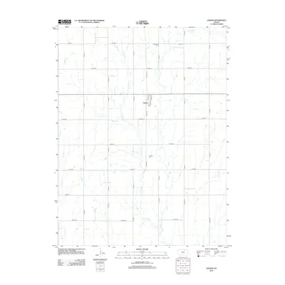
2012 Map of Agenda
USGS Topo · Published 2012About this map
The small community of Agenda serves as the central point of this North Central Kansas survey, surrounded by a landscape defined by the drainage of Elk Cr and its tributaries. The rectilinear grid of county roads, including the historically named Wagon Rd at the southern edge, speaks to the enduring agrarian structure of Republic County. Genealogy researchers can locate two key burial sites: Willoughby Cem in the northern section and Agenda Cem south of the main town site. The map documents the intricate branching of W Fork Elk Cr and Upton Cr, which carve through the plains and dictate the placement of local thoroughfares. This 2012 record preserves the placement of village streets like Railroad ST and Main ST, reflecting the foundational layout of this rural Kansas settlement.
Find a feature on this map
33 named features on this map. Tap any name to fly to it.
Don’t see what you’re looking for? This feature index may not catch every label — zoom into the map to look around manually.
Map Details
Editions of this 2012 Agenda Map
This is the sole edition of this map. No revisions or reprints were ever made.
Other maps of this area

1892 · Concordia
USGS Topo · 1:125,000

1893 · Washington
USGS Topo · 1:125,000

1955 · Manhattan
USGS Topo · 1:250,000

1956 · Manhattan
USGS Topo · 1:250,000

1957 · Manhattan
USGS Topo · 1:250,000

1965 · Clifton
USGS Topo · 1:24,000

1965 · Brantford
USGS Topo · 1:24,000

1965 · Wayne
USGS Topo · 1:24,000
1965 · Clyde
USGS Topo · 1:24,000

1965 · Agenda
USGS Topo · 1:24,000