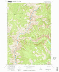
1962 Map of Aggipah Mtn
USGS Topo · Published 1986About this map
The Middle Fork Salmon River carves a deep path through this 1962 field-checked survey of central Idaho, marking the jagged intersection of the Salmon National Forest and the Payette National Forest. This high-altitude wilderness is defined by the sharp elevations of the Bighorn Crags and the Aggipah Mtn summit. The map documents the primitive infrastructure of the era, centered on the Stoddard Trail and the strategically placed Stoddard Creek Lookout. The river's character is evidenced by numerous named white-water features, including Ouzel Rapids, Roadside Rapids, and Porcupine Rapids. Geologic and geographic interest is concentrated around Ship Island and the headwaters of several drainages like Ship Island Creek and Waterfall Creek, showing the drainage patterns that feed into the Salmon River system.
Find a feature on this map
28 named features on this map. Tap any name to fly to it.
Don’t see what you’re looking for? This feature index may not catch every label — zoom into the map to look around manually.
Map Details
Editions of this 1962 Aggipah Mtn Map
3 editions found
Other maps of this area

1956 · Elk City
USGS Topo · 1:250,000

1960 · Elk City
USGS Topo · 1:250,000

1962 · Hoodoo Meadows
USGS Topo · 1:24,000

1962 · Long Tom Mtn
USGS Topo · 1:24,000

1962 · Puddin Mtn
USGS Topo · 1:24,000

1962 · Papoose Peak
USGS Topo · 1:24,000

1962 · Aggipah Mtn
USGS Topo · 1:24,000

1962 · Mt Mc Guire
USGS Topo · 1:24,000

1962 · Dave Lewis Peak
USGS Topo · 1:24,000

1962 · Butts Creek Point
USGS Topo · 1:24,000