
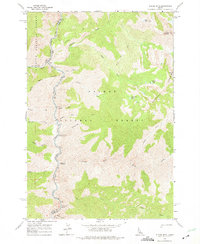
1962 Map of Puddin Mtn
USGS Topo · Published 1964About this map
The Middle Fork Salmon River carves through the heart of the Idaho wilderness on this early 1960s survey, marking the boundary between Valley and Lemhi counties. This landscape is defined by the high elevations of the Bighorn Crags and the towering Puddin Mountain. Remote access is facilitated by a network of wilderness routes, including the Middle Fork Trail and early crossings like the Big Creek Bridge and Bighorn Bridge. The area serves as a significant recreational and conservation zone, containing the Payette National Forest and Salmon National Forest. Early backcountry infrastructure is visible at the Rattlesnake Or Campground and Wilson Creek Campground, while the river's dynamic character is noted at the Jack Creek Rapids. A series of high-altitude alpine basins hold West Puddin Lake, Plateau Lake, and South Fork Lake, feeding a complex drainage system of creeks including Kimmel and Wilson Creek.
Find a feature on this map
36 named features on this map. Tap any name to fly to it.
Don’t see what you’re looking for? This feature index may not catch every label — zoom into the map to look around manually.
Map Details
Editions of this 1962 Puddin Mtn Map
2 editions found
Other maps of this area

1930 · Casto
USGS Topo · 1:125,000

1956 · Elk City
USGS Topo · 1:250,000

1957 · Challis
USGS Topo · 1:250,000

1960 · Elk City
USGS Topo · 1:250,000

1960 · Challis
USGS Topo · 1:250,000

1962 · Bear Creek Point
USGS Topo · 1:24,000

1962 · Hoodoo Meadows
USGS Topo · 1:24,000

1962 · Papoose Peak
USGS Topo · 1:24,000

1962 · Aggipah Mtn
USGS Topo · 1:24,000

1962 · Mt Mc Guire
USGS Topo · 1:24,000