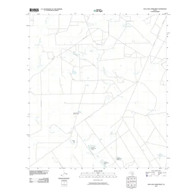
2010 Map of Agua Azul Creek West
USGS Topo · Published 2010About this map
Water management dominates this arid landscape in south Texas, where a complex network of seasonal drainages and man-made impoundments define the local geography. Several significant water control structures appear, including the L E Bruni Lake Number 1 Dam, L E Bruni Lake Number 2 Dam, and L E Bruni Lake Number 4 Dam, alongside the Rhodes Lake Dam. These features illustrate the vital role of water storage for ranching and agriculture in Webb County.
Find a feature on this map
14 named features on this map. Tap any name to fly to it.
Don’t see what you’re looking for? This feature index may not catch every label — zoom into the map to look around manually.
Map Details
Editions of this 2010 Agua Azul Creek West Map
This is the sole edition of this map. No revisions or reprints were ever made.
Other maps of this area

1933 · Becerra Creek
USGS Topo · 1:62,500

1940 · Aguilares
USGS Topo · 1:62,500

1940 · Mogotes Hill
USGS Topo · 1:62,500

1942 · San Ygnacio
USGS Topo · 1:62,500

1956 · Mogotes Hill
USGS Topo · 1:62,500

1956 · Laredo
USGS Topo · 1:250,000

1980 · Blancas Creek North
USGS Topo · 1:24,000
1980 · Agua Azul Creek East
USGS Topo · 1:24,000
1980 · Mirando City
USGS Topo · 1:24,000
1980 · Agua Azul Creek West
USGS Topo · 1:24,000