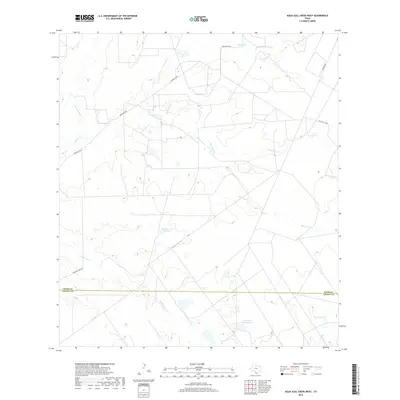
2019 Map of Agua Azul Creek West
USGS Topo · Published 2019About this map
The Webb Co and Zapata Co boundary line divides this South Texas landscape, defined by an intricate network of intermittent drainages and ranching infrastructure. Arroyos and creeks such as Cerrito Cr, San Juanito Cr, and Aqua Azul Cr carve across the terrain, leading toward livestock water sources like Los Lasos Tank and Jordan Tank. The presence of Hubbard Lake Number 1 and L E Bruni Lake Number 2 highlights the regional reliance on managed water catchments in this semi-arid environment. Local transport is dictated by a few key corridors, including the Mangana-Hein Rd and Ranch Rd 7070B, which connect isolated ranching operations. This modern survey reflects the enduring spatial patterns of Texas brush country, where family-named landmarks and water management dictate the use of the land.
Find a feature on this map
16 named features on this map. Tap any name to fly to it.
Don’t see what you’re looking for? This feature index may not catch every label — zoom into the map to look around manually.
Map Details
Editions of this 2019 Agua Azul Creek West Map
This is the sole edition of this map. No revisions or reprints were ever made.
Other maps of this area

1933 · Becerra Creek
USGS Topo · 1:62,500

1940 · Aguilares
USGS Topo · 1:62,500

1940 · Mogotes Hill
USGS Topo · 1:62,500

1942 · San Ygnacio
USGS Topo · 1:62,500

1956 · Mogotes Hill
USGS Topo · 1:62,500

1956 · Laredo
USGS Topo · 1:250,000

1980 · Blancas Creek North
USGS Topo · 1:24,000
1980 · Agua Azul Creek East
USGS Topo · 1:24,000
1980 · Mirando City
USGS Topo · 1:24,000
1980 · Agua Azul Creek West
USGS Topo · 1:24,000