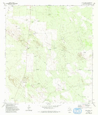
1972 Map of Agua Nueva
USGS Topo · Published 1993About this map
The arid ranchlands of Jim Hogg Co. are defined by an intricate network of water management and livestock infrastructure. Settlement centers around Agua Nueva and the Palomas Ranch, while the surrounding landscape is marked by dozens of family-named water sources, such as San Carlos Windmill and San Guadalupe Windmill. This 1970s landscape shows the transition of traditional ranching into the modern era, with a Pipeline and a Landing Strip cutting across the brush-covered terrain.
Find a feature on this map
39 named features on this map. Tap any name to fly to it.
Don’t see what you’re looking for? This feature index may not catch every label — zoom into the map to look around manually.
Map Details
Editions of this 1972 Agua Nueva Map
2 editions found
Other maps of this area

1921 · Falfurrias
USGS Topo · 1:125,000

1938 · Agua Nueva
USGS Topo · 1:62,500

1939 · Encantada
USGS Topo · 1:62,500

1949 · Mc Allen
USGS Topo · 1:250,000

1954 · McAllen
USGS Topo · 1:250,000

1956 · Laredo
USGS Topo · 1:250,000

1957 · Mc Allen
USGS Topo · 1:250,000

1962 · McAllen
USGS Topo · 1:250,000

1968 · Palomas Ranch SW
USGS Topo · 1:24,000
1972 · Alta Vista Ranch SW
USGS Topo · 1:24,000