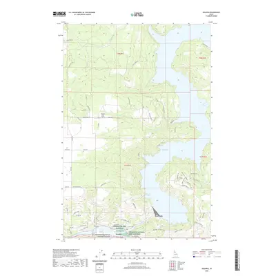
2020 Map of Ahsahka
USGS Topo · Published 2020About this map
Ahsahka sits at the confluence of the Clearwater River and the North Fork Clearwater River, serving as a focal point for this Clearwater County landscape. The area is defined by the massive footprint of the Dworshak Reservoir, which dominates the northern and eastern portions of the map, creating intricate shorelines at Big Eddy and Little Bay. The presence of the Dworshak National Fish Hatchery and the Clearwater Fish Hatchery near the river junction highlights the region's long-standing connection to local river ecology and fisheries management. Higher elevations are marked by the Eureka Ridge and Teakean Butte, while portions of the Nez Perce National Historical Park reflect the cultural and historical significance of this terrain. Local aviation and utility are represented by the Freeman Creek Airport and the nearby Bruce Eddy recreation area, documenting a landscape that balances industrial fishery operations with wilderness and water-based recreation.
Find a feature on this map
70 named features on this map. Tap any name to fly to it.
Don’t see what you’re looking for? This feature index may not catch every label — zoom into the map to look around manually.
Map Details
Editions of this 2020 Ahsahka Map
This is the sole edition of this map. No revisions or reprints were ever made.
Other maps of this area

1924 · Kamiah
USGS Topo · 1:125,000

1955 · Pullman
USGS Topo · 1:250,000

1958 · Pullman
USGS Topo · 1:250,000

1961 · Ahsahka
USGS Topo · 1:62,500

1967 · Peck
USGS Topo · 1:24,000

1967 · Orofino West
USGS Topo · 1:24,000

1967 · Orofino East
USGS Topo · 1:24,000

1969 · Elk Creek Falls
USGS Topo · 1:24,000
1969 · Dent
USGS Topo · 1:24,000

1981 · Orofino
USGS Topo · 1:100,000