1981 Map of Orofino
USGS Topo · Published 1982About this map
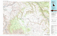
The Nez Perce Indian Reservation dominates this 1980s landscape, illustrating a complex network of canyons and high plateaus where the Clearwater River and Snake River meet. The map documents the vital rail infrastructure of the Pacific Northwest, specifically the Union Pacific and Camas Prairie lines that serviced agricultural hubs like Craigmont, Nezperce, and Cottonwood. Settlement patterns are clearly defined, ranging from the urban expansion at Lewiston Orchards to the isolated communities of Keuterville and Westlake.
Find a feature on this map
61 named features on this map. Tap any name to fly to it.
Don’t see what you’re looking for? This feature index may not catch every label — zoom into the map to look around manually.
Map Details
Editions of this 1981 Orofino Map
This is the sole edition of this map. No revisions or reprints were ever made.
Historical Maps of Lewiston Through Time
1 maps found