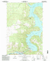
1994 Map of Ahsahka
USGS Topo · Published 1997About this map
Ahsahka stands at the confluence of the North Fork Clearwater River and the main Clearwater River, serving as a focal point for Idaho's inland waterway management in the mid-1990s. The landscape is dominated by the Dworshak Reservoir, a massive impoundment that transformed the steep river valleys into a complex of bays and recreational points like the Bruces Eddy Launch Area. This era shows a significant investment in fisheries and conservation, evidenced by the large-scale Dworshak National Fish Hatchery and the Clearwater Anadromous Fish Hatchery located near the town. Historical and cultural significance is rooted in the Nez Perce Indian Reservation Boundary and the Lewis Clark Canoe Camp State Park, which commemorates the expedition's local history. The map also highlights industrial and utility infrastructure, including a Power House, Gaging Station, and a prominent Landing Strip carved into the plateau above Freeman Creek.
Find a feature on this map
24 named features on this map. Tap any name to fly to it.
Don’t see what you’re looking for? This feature index may not catch every label — zoom into the map to look around manually.
Map Details
Editions of this 1994 Ahsahka Map
This is the sole edition of this map. No revisions or reprints were ever made.
Other maps of this area

1924 · Kamiah
USGS Topo · 1:125,000

1955 · Pullman
USGS Topo · 1:250,000

1958 · Pullman
USGS Topo · 1:250,000

1961 · Ahsahka
USGS Topo · 1:62,500

1967 · Peck
USGS Topo · 1:24,000

1967 · Orofino West
USGS Topo · 1:24,000

1967 · Orofino East
USGS Topo · 1:24,000

1969 · Elk Creek Falls
USGS Topo · 1:24,000
1969 · Dent
USGS Topo · 1:24,000

1981 · Orofino
USGS Topo · 1:100,000