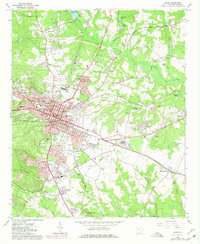
1964 Map of Aiken
USGS Topo · Published 1980About this map
Aiken's specialized sporting and educational landscape is clearly defined in this mid-1960s survey, updated with 1970s revisions. The city’s equestrian identity is represented by the Aiken Mile Track, Steeplechase, and several polo grounds like the Whitney Polo Field. The urban core is dense with significant local institutions, including Schofield High Sch, St Angela Academy, and the Univ of SC (Aiken Br). To the west, the city limits touch the Municipal Golf Course, while the Southern railroad line bisects the town, connecting it to smaller outlying communities like Montmorenci and Couchton.
Find a feature on this map
120 named features on this map. Tap any name to fly to it.
Don’t see what you’re looking for? This feature index may not catch every label — zoom into the map to look around manually.
Map Details
Editions of this 1964 Aiken Map
4 editions found
Other maps of this area

1920 · Aiken
USGS Topo · 1:48,000

1920 · Talatha
USGS Topo · 1:48,000

1921 · Augusta
USGS Topo · 1:62,500

1921 · Aiken
USGS Topo · 1:62,500

1921 · Talatha
USGS Topo · 1:62,500

1923 · Warrenville
USGS Topo · 1:48,000

1928 · Warrenville
USGS Topo · 1:62,500

1943 · Aiken
USGS Topo · 1:62,500

1943 · Augusta East
USGS Topo · 1:125,000

1943 · Warrenville
USGS Topo · 1:62,500