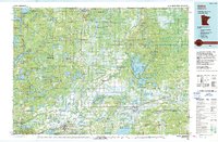
1994 Map of Aitkin
USGS Topo · Published 1994About this map
The Mississippi River winds through this 1994 record of the lake-rich landscape of Aitkin County and its neighbors. The region is defined by its extensive protected lands and water management areas, including the Rice Lake National Wildlife Refuge and the Savanna Portage State Park. Settlement patterns reflect the influence of the Soo Line railroad, which connects the hub at McGregor to smaller stops like Tamarack and Palisade. To the southwest, the mining heritage near Crosby and Ironton is visible alongside the Mille Lacs Lake Indian Reservation. The map details a complex network of wetlands and diversion projects, notably the Flood Diversion Channel, which manages the water levels of the surrounding marshes and numerous lakes like Big Sandy Lake and Lake Minnewawa.
Find a feature on this map
72 named features on this map. Tap any name to fly to it.
Don’t see what you’re looking for? This feature index may not catch every label — zoom into the map to look around manually.
Map Details
Editions of this 1994 Aitkin Map
This is the sole edition of this map. No revisions or reprints were ever made.
Other maps of this area

1912 · Deerwood
USGS Topo · 1:62,500

1913 · Cuyuna
USGS Topo · 1:62,500

1914 · Deerwood
USGS Topo · 1:62,500

1914 · Aitkin
USGS Topo · 1:62,500

1915 · Aitkin
USGS Topo · 1:62,500

1915 · Cuyuna
USGS Topo · 1:62,500

1915 · Brainerd
USGS Topo · 1:62,500

1916 · Wealthwood
USGS Topo · 1:62,500

1918 · Brainerd
USGS Topo · 1:62,500

1953 · Duluth
USGS Topo · 1:250,000