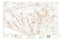
1967 Map of Ajo
USGS Topo · Published 1967About this map
The Gila River valley and its surrounding desert basins define this mid-century portrait of southern Arizona's transition from agricultural river bottoms to vast military training grounds. The Southern Pacific railroad remains the primary infrastructure spine, connecting small outposts like Gila Bend and Tacna while serving as the anchor for the region's early growth. Extensive aviation networks from the Cold War era are prominent, including the Gila Bend Air Force Auxiliary Field and a series of numbered remote sites like Luke AF No 11.
Find a feature on this map
172 named features on this map. Tap any name to fly to it.
Don’t see what you’re looking for? This feature index may not catch every label — zoom into the map to look around manually.
Map Details
Editions of this 1967 Ajo Map
This is the sole edition of this map. No revisions or reprints were ever made.
Other maps of this area
1913 · Maricopa
USGS Topo · 1:62,500
1914 · Gila Butte
USGS Topo · 1:62,500
1915 · Maricopa
USGS Topo · 1:62,500
1917 · Gila Butte
USGS Topo · 1:62,500
1922 · Casa Grande
USGS Topo · 1:62,500
1924 · Casa Grande
USGS Topo · 1:62,500
1926 · Wellton
USGS Topo · 1:62,500
1926 · Mohawk
USGS Topo · 1:62,500
1927 · Aguila Mountains
USGS Topo · 1:48,000
1927 · Kim
USGS Topo · 1:62,500