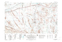
1982 Map of Ajo
USGS Topo · Published 1982About this map
Ajo stands as the primary hub in this vast Sonoran desert landscape, where mining and ranching history meet international borders and expansive federal lands. The 1982 survey illustrates a region defined by massive conservation and military holdings, including the Cabeza Prieta National Wildlife Refuge and Organ Pipe Cactus National Monument. To the north, the Gila River corridor supports a string of settlements like Gila Bend, Theba, and Sentinel along the Southern Pacific railroad line. The map captures the unique tri-point of the Papago Indian Reservation (Tohono O'odham), the Luke Air Force Range, and the Mexican border at Lukeville. Researchers can trace the network of desert washes such as Growler Wash and San Cristobal Wash that have dictated travel routes through the Mohawk Mountains and Sauceda Mountains for centuries.
Find a feature on this map
106 named features on this map. Tap any name to fly to it.
Don’t see what you’re looking for? This feature index may not catch every label — zoom into the map to look around manually.
Map Details
Editions of this 1982 Ajo Map
This is the sole edition of this map. No revisions or reprints were ever made.
Other maps of this area

1913 · Maricopa
USGS Topo · 1:62,500

1914 · Gila Butte
USGS Topo · 1:62,500

1915 · Maricopa
USGS Topo · 1:62,500

1917 · Gila Butte
USGS Topo · 1:62,500

1922 · Casa Grande
USGS Topo · 1:62,500

1924 · Casa Grande
USGS Topo · 1:62,500

1926 · Wellton
USGS Topo · 1:62,500

1926 · Mohawk
USGS Topo · 1:62,500

1927 · Aguila Mountains
USGS Topo · 1:48,000

1927 · Kim
USGS Topo · 1:62,500