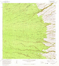
1981 Map of Akaka Falls
USGS Topo · Published 1981About this map
Akaka Falls State Park and the spectacular Akaka Falls define this coastal slope on the Big Island during the early 1980s. The landscape is characterized by a dense network of gulches and streams, including Hakalau Stream and Honolii Stream, that carve through the Hilo Reserve Forest toward the Pacific. The pattern of settlement is clearly visible through the numerous agricultural subdivisions, such as Honomu Homesteads and Kaieie Homesteads, which represent the historical land distribution for small-scale farming in the region.
Find a feature on this map
75 named features on this map. Tap any name to fly to it.
Don’t see what you’re looking for? This feature index may not catch every label — zoom into the map to look around manually.
Map Details
Editions of this 1981 Akaka Falls Map
2 editions found
Other maps of this area

1915 · Honomu
USGS Topo · 1:62,500

1917 · Hilo
USGS Topo · 1:62,500

1930 · Humuula
USGS Topo · 1:62,500

1932 · Hilo
USGS Topo · 1:62,500

1954 · Hawaii North
USGS Topo · 1:250,000

1956 · Pua Akala
USGS Topo · 1:24,000

1956 · Keanakolu
USGS Topo · 1:24,000

1956 · Upper Piihonua
USGS Topo · 1:24,000

1959 · Hawaii North
USGS Topo · 1:250,000

1961 · Hawaii North
USGS Topo · 1:250,000