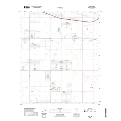
2020 Map of Akela
USGS Topo · Published 2020About this map
Akela and the surrounding high desert plains of Akela Flats define this section of Luna County, where the landscape is organized by a meticulous grid of residential and access roads. The naming convention of these thoroughfares reflects the local flora, with routes such as Prickly Pear Rd, Joshua Rd, and Cholla Rd crisscrossing the terrain. This modern survey shows a transition in land use, from the structured townsite area near the highway and railroad corridor to more remote stretches like Happiness Ave SE. The presence of labels like Taxiway SE and Kiowas suggests specific infrastructure and localized developments within the broader t24s r6w and t24s r5w township divisions. The map provides a clear view of how the area has been subdivided for settlement, emphasizing a desert community shaped by planned road networks and proximity to regional transport lines.
Find a feature on this map
95 named features on this map. Tap any name to fly to it.
Don’t see what you’re looking for? This feature index may not catch every label — zoom into the map to look around manually.
Map Details
Editions of this 2020 Akela Map
This is the sole edition of this map. No revisions or reprints were ever made.
Other maps of this area

1899 · Deming
USGS Topo · 1:125,000

1915 · Deming
USGS Topo · 1:125,000

1955 · Las Cruces
USGS Topo · 1:250,000

1958 · Las Cruces
USGS Topo · 1:250,000

1964 · Gym Peak
USGS Topo · 1:24,000

1964 · Florida Gap
USGS Topo · 1:24,000

1965 · Carne
USGS Topo · 1:24,000

1972 · Myndus
USGS Topo · 1:24,000

1972 · Cambray
USGS Topo · 1:24,000
1972 · X-7 Ranch
USGS Topo · 1:24,000