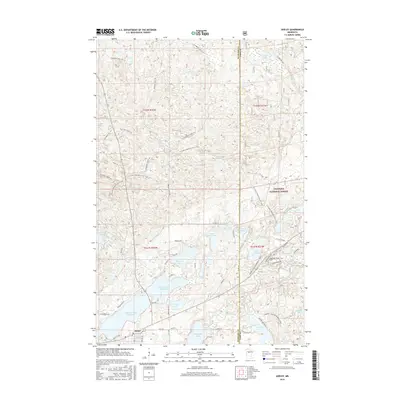
2016 Map of Akeley
USGS Topo · Published 2016About this map
Akeley sits at the southwestern edge of a landscape defined by an intricate network of glacial lakes and forest corridors in northern Minnesota. This 2016 survey highlights the expansive Chippewa National Forest and the diverse recreational infrastructure that winds through the Hubbard and Cass County borderlands. The N Country National Scenic Trail and the Snoway 1 Gia Snowmobile Trail cut across the rolling terrain, while specialized sites like Shingobee Ski and the Shingobee Spur F Ski occupy the hills near the Shingobee River. Water remains the dominant geographic feature, from the large expanse of Eleventh Crow Wing Lake to more secluded basins like Rickles Lake, Cramer Lake, and Lake Alice. Numerous forest roads, including Kabekona Forest Rd and Blue Trl, provide access to these remote waterways, reflecting the region's enduring character as a destination for timber management and outdoor heritage.
Find a feature on this map
54 named features on this map. Tap any name to fly to it.
Don’t see what you’re looking for? This feature index may not catch every label — zoom into the map to look around manually.
Map Details
Editions of this 2016 Akeley Map
This is the sole edition of this map. No revisions or reprints were ever made.
Other maps of this area

1953 · Brainerd
USGS Topo · 1:250,000

1954 · Bemidji
USGS Topo · 1:250,000

1957 · Brainerd
USGS Topo · 1:250,000

1957 · Bemidji
USGS Topo · 1:250,000

1958 · Bemidji
USGS Topo · 1:250,000

1958 · Brainerd
USGS Topo · 1:250,000

1965 · Brainerd
USGS Topo · 1:250,000

1970 · Hackensack
USGS Topo · 1:24,000

1970 · Nevis
USGS Topo · 1:24,000
1970 · Crystal Lake
USGS Topo · 1:24,000