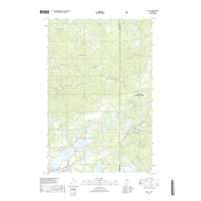
2019 Map of Akeley
USGS Topo · Published 2019About this map
The town of Akeley serves as the southern anchor for this map, where the street grid of Broadway St W and Pleasant Ave NE meets the shore of Eleventh Crow Wing Lake. Situated at the border of Hubbard and Cass Counties, the landscape is dominated by a dense network of glacial lakes including Shingobee Lake and Lake Alice. Much of the northern and eastern terrain is protected within the Chippewa National Forest, which is crisscrossed by specialized recreational infrastructure. Recreational use is a defining characteristic of this area, evidenced by the presence of the North Country National Scenic Trail, the Shingobee Ski area, and the Snoway 1 GIA Snowmobile Trail. Forest access is facilitated by numerous unpaved routes such as Kabekona Forest Rd and Steamboat Forest Rd, reflecting the region's history of timber management and modern-day outdoor tourism.
Find a feature on this map
64 named features on this map. Tap any name to fly to it.
Don’t see what you’re looking for? This feature index may not catch every label — zoom into the map to look around manually.
Map Details
Editions of this 2019 Akeley Map
This is the sole edition of this map. No revisions or reprints were ever made.
Other maps of this area

1953 · Brainerd
USGS Topo · 1:250,000

1954 · Bemidji
USGS Topo · 1:250,000

1957 · Brainerd
USGS Topo · 1:250,000

1957 · Bemidji
USGS Topo · 1:250,000

1958 · Bemidji
USGS Topo · 1:250,000

1958 · Brainerd
USGS Topo · 1:250,000

1965 · Brainerd
USGS Topo · 1:250,000

1970 · Hackensack
USGS Topo · 1:24,000

1970 · Nevis
USGS Topo · 1:24,000
1970 · Crystal Lake
USGS Topo · 1:24,000