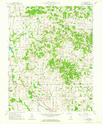
1963 Map of Akin
USGS Topo · Published 1964About this map
The Southern Illinois landscape between Akin and West End is captured here during a period of transition in the early 1960s. The terrain is marked by the complex drainage systems of Middle Fork Saline River and Rector Creek, where the wooded hills of South Flannigan meet the agricultural flats of Eastern township. Small rural communities and church-centered settlements like Rural Hill and West Rural Hill are connected by a network of winding country roads and the Illinois Central railroad, which cuts through the southwestern corner near Ferber. Numerous family-named cemeteries and landmarks, such as Good Hope Cem, Little Springs Cem Ch, and Oak Grove Ch, serve as significant markers for genealogists tracing the legacy of Hamilton and Saline counties. The map also documents the prevalence of the oil industry in this era, with numerous wells scattered across the north and central sectors.
Find a feature on this map
38 named features on this map. Tap any name to fly to it.
Don’t see what you’re looking for? This feature index may not catch every label — zoom into the map to look around manually.
Map Details
Editions of this 1963 Akin Map
This is the sole edition of this map. No revisions or reprints were ever made.
Other maps of this area

1908 · Galatia
USGS Topo · 1:62,500

1909 · West Frankfort
USGS Topo · 1:62,500

1938 · Galatia
USGS Topo · 1:62,500

1939 · Ina
USGS Topo · 1:62,500

1941 · West Frankfort
USGS Topo · 1:62,500

1942 · McLeansboro
USGS Topo · 1:62,500

1943 · Ina
USGS Topo · 1:62,500

1945 · McLeansboro
USGS Topo · 1:62,500

1949 · Paducah
USGS Topo · 1:250,000

1950 · Paducah
USGS Topo · 1:250,000